# Drone Inspection Services for Infrastructure: Faster, Safer, and More Accurate Assessments
Infrastructure forms the backbone of modern society—bridges carry commuters, pipelines deliver energy, cell towers keep us connected, and power lines light our homes. Keeping this critical infrastructure safe and operational requires regular, thorough inspections. Traditionally, these inspections have been time-consuming, expensive, and dangerous. Today, **drone inspection services for infrastructure** are changing the game entirely.
## The Challenge of Traditional Infrastructure Inspections
Conventional infrastructure inspections often require scaffolding, rope access teams, bucket trucks, or even temporary shutdowns. Inspectors must physically access hard-to-reach areas—the underside of a bridge deck, the top of a transmission tower, or the interior of a confined pipeline corridor. This approach carries significant risks:
- **Worker safety hazards** from working at height or in confined spaces
- **High labor and equipment costs** for access rigging and specialized crews
- **Extended downtime** that disrupts operations and public services
- **Incomplete data** due to limited vantage points and human fatigue
For aging infrastructure across the United States, these challenges are compounded by the sheer scale of assets that need regular attention. The American Society of Civil Engineers consistently grades U.S. infrastructure with a near-failing score, underscoring the urgency of more efficient inspection methods.
## How Drone Inspection Services Transform Infrastructure Maintenance
FAA-certified drone pilots equipped with high-resolution cameras, thermal imaging sensors, and LiDAR technology can now inspect infrastructure assets in a fraction of the time—and at a fraction of the cost—of traditional methods.
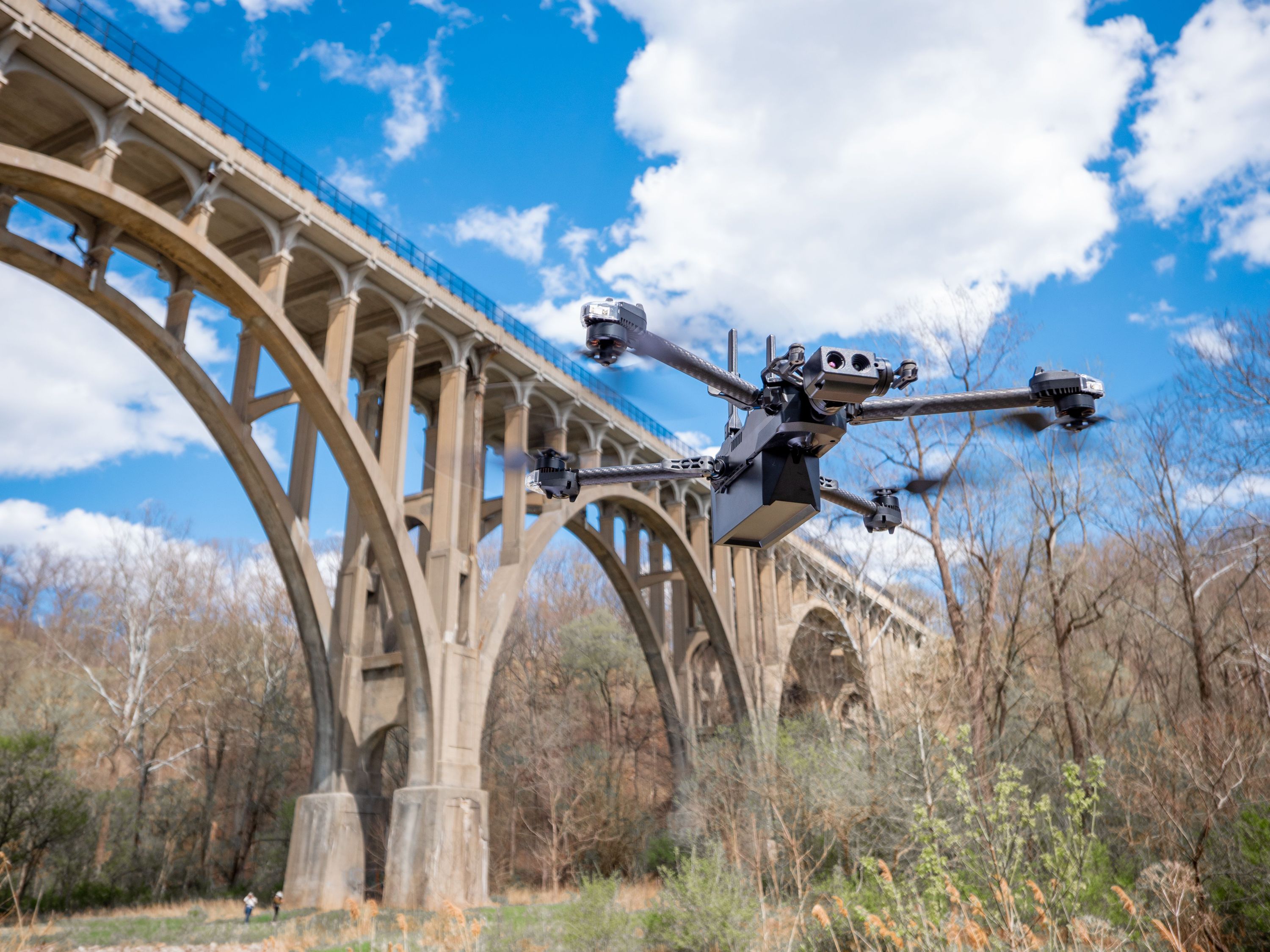
### Bridge Inspections
Bridges require detailed visual inspections of decks, girders, bearings, piers, and abutments. Drones can fly beneath bridge decks, capturing 4K video and high-resolution still images of every structural element without lane closures or under-bridge inspection vehicles. **Thermal drone cameras** can even detect moisture intrusion and delamination in concrete that is invisible to the naked eye, enabling engineers to prioritize repairs before minor issues become catastrophic failures.
### Power Line and Transmission Tower Inspections
Inspecting miles of power lines and hundreds of transmission towers is a logistical challenge for utility companies. Drone services allow crews to survey entire transmission corridors rapidly, identifying damaged insulators, corroded hardware, vegetation encroachment, and structural defects. Thermal imaging drones excel at detecting **hot spots on electrical components**—a critical early warning sign of equipment failure that can prevent outages and wildfires.
### Pipeline and Right-of-Way Surveys
For oil, gas, and water pipeline operators, maintaining right-of-way corridors and detecting leaks or ground movement is essential. Drones equipped with multispectral and thermal sensors can patrol pipeline routes efficiently, flagging anomalies such as ground subsidence, unauthorized encroachments, or vegetation stress patterns that may indicate a subsurface leak. This aerial perspective provides data that ground crews simply cannot gather as quickly or comprehensively.
### Cell Tower and Communication Infrastructure
Cell towers must be inspected regularly to ensure structural integrity and equipment functionality. Sending climbers up a 200-foot tower is inherently dangerous and time-consuming. Drone inspections allow technicians to assess antenna mounts, cable management, lighting systems, and structural members safely from the ground, with detailed imagery delivered digitally for engineering review.
### Retaining Walls, Dams, and Levees
Large earthen and concrete structures like dams, levees, and retaining walls benefit enormously from aerial drone surveys. Drones can capture **photogrammetric 3D models** of entire structures, enabling engineers to track settlement, cracking, and erosion over time with millimeter-level precision. Comparing models from successive inspections reveals changes that would be nearly impossible to detect through periodic visual walkthroughs alone.
## Key Benefits of Drone Infrastructure Inspections
**1. Enhanced Safety**
By removing workers from hazardous environments—heights, confined spaces, live traffic zones—drone inspections dramatically reduce the risk of workplace injuries and fatalities.
**2. Significant Cost Savings**
Eliminating the need for scaffolding, bucket trucks, lane closures, and large inspection crews translates directly into lower project costs. Many infrastructure owners report **50–80% cost reductions** compared to traditional inspection methods.
**3. Faster Turnaround**
A drone can survey a bridge or transmission line segment in hours rather than days. Rapid data collection means faster reporting, quicker decision-making, and reduced asset downtime.
**4. Superior Data Quality**
High-resolution imagery, thermal data, and 3D point clouds provide a richer, more objective record than manual inspection notes alone. This data integrates seamlessly with asset management systems and GIS platforms.
**5. Regulatory Compliance**
FAA Part 107-certified drone pilots operate within established safety regulations, ensuring that all aerial inspections are conducted legally and professionally.
## What to Expect from a Professional Drone Infrastructure Inspection
When you partner with a qualified drone services provider, the process typically includes:
1. **Pre-flight planning** – Airspace authorization, site assessment, and mission planning tailored to your specific asset
2. **Data capture** – Systematic flight patterns to ensure complete coverage using the appropriate sensor suite
3. **Data processing** – Stitching imagery into orthomosaics, generating 3D models, and analyzing thermal data
4. **Deliverables** – Detailed inspection reports with annotated imagery, condition ratings, and recommended actions
5. **Ongoing monitoring** – Scheduled repeat flights to track asset condition over time
## Why Choose CAAP Solutions for Infrastructure Drone Inspections
At CAAP Solutions, our FAA-certified drone pilots bring deep expertise in infrastructure inspection across bridges, utilities, pipelines, and communication towers. We combine cutting-edge drone technology with rigorous data analysis to deliver actionable insights that help infrastructure owners make smarter maintenance decisions.
Whether you manage a portfolio of bridges for a state DOT, oversee a regional utility network, or operate critical pipeline infrastructure, our drone inspection services provide the visibility you need—safely, efficiently, and affordably.
**Ready to modernize your infrastructure inspection program?** Contact CAAP Solutions today to discuss your project and receive a customized quote.
---
*Investing in drone inspection technology isn't just about cutting costs—it's about protecting the infrastructure that communities depend on every day. With faster detection of defects and deterioration, drone services help extend asset lifespans, prevent failures, and keep the public safe.*