# Drone Services for Construction: How Aerial Technology Is Transforming Job Sites
The construction industry has always been driven by innovation—from the introduction of heavy machinery to the adoption of Building Information Modeling (BIM). Today, a new technology is reshaping how construction projects are planned, managed, and delivered: **professional drone services**. FAA-certified drone pilots are giving construction companies an unprecedented aerial advantage, and the results speak for themselves.
## Why Construction Companies Are Turning to Drone Technology
Construction projects are complex, time-sensitive, and expensive. Delays, miscommunications, and inaccurate site data can cost thousands—sometimes millions—of dollars. Drone services address these pain points head-on by delivering high-resolution aerial imagery, precise topographic data, and real-time progress documentation that traditional ground-based methods simply cannot match.
According to industry research, construction companies that integrate drone technology into their workflows report up to a **55% reduction in survey time** and significant improvements in project accuracy. Whether you're managing a commercial development, a residential subdivision, or a large-scale infrastructure build, aerial drone services offer a competitive edge that's hard to ignore.
## Key Drone Services for the Construction Industry
### 1. Pre-Construction Site Surveys and Topographic Mapping
Before a single shovel hits the ground, accurate site data is essential. Drone-based aerial surveys can capture detailed topographic maps, elevation models, and orthomosaic imagery of a construction site in a fraction of the time required by traditional survey crews.
Using photogrammetry software, FAA-certified drone pilots can generate:
- **Digital Elevation Models (DEMs)** for grading and drainage planning
- **Orthomosaic maps** with centimeter-level accuracy
- **3D point clouds** for volumetric calculations and earthwork estimates
- **Contour maps** to support civil engineering design
This data integrates seamlessly with AutoCAD, Civil 3D, and BIM platforms, giving your engineering and design teams the precise foundation they need from day one.
### 2. Construction Progress Monitoring
Keeping stakeholders informed and projects on schedule is one of the biggest challenges in construction management. Regular drone flyovers provide a consistent, objective record of site progress that photos taken from the ground simply can't replicate.
With scheduled aerial progress monitoring, construction managers can:
- Compare current site conditions against project plans and timelines
- Identify delays or deviations early before they become costly problems
- Share high-quality aerial imagery and video with clients, investors, and project owners
- Maintain a visual archive of the entire construction lifecycle
This level of transparency builds client trust and keeps all parties aligned throughout the project.
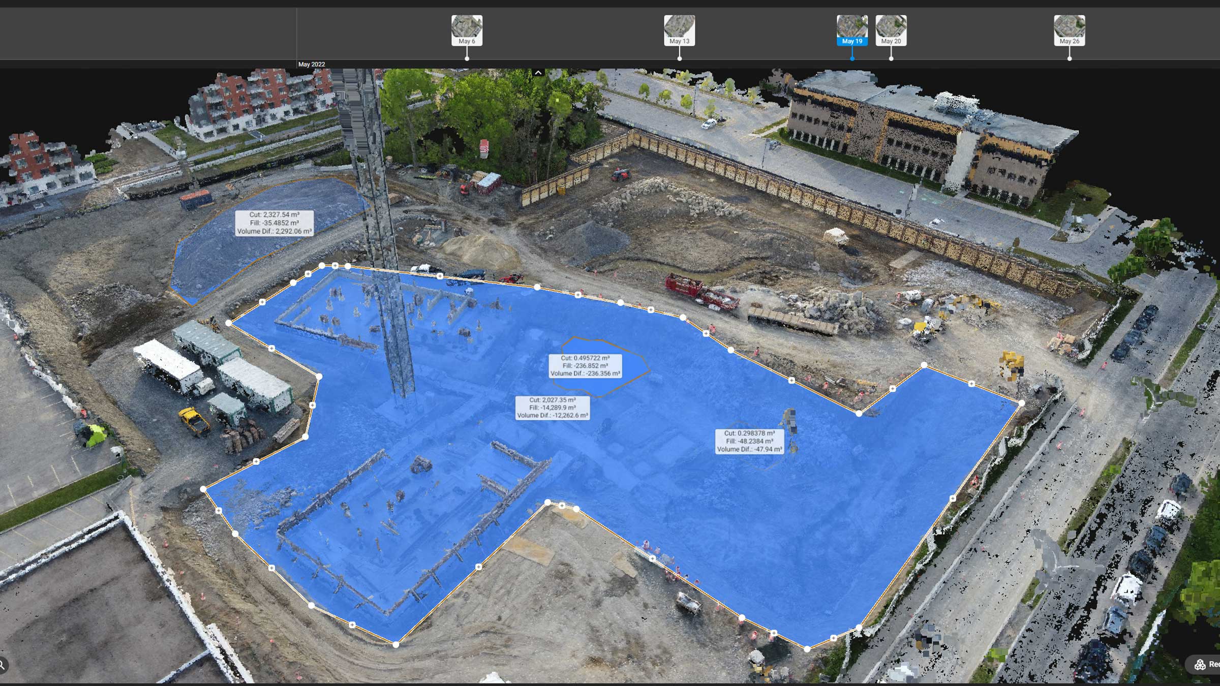
### 3. Stockpile and Volumetric Measurements
Accurately measuring stockpiles of materials—dirt, gravel, sand, concrete aggregate—is a time-consuming task that traditionally requires manual surveying. Drone services can capture this data in minutes with remarkable precision.
Aerial volumetric measurements help construction companies:
- Track material inventory in real time
- Reduce over-ordering and material waste
- Verify contractor billing for earthwork and excavation
- Improve cost forecasting and budget management
### 4. Safety Inspections and Hazard Identification
Construction sites are inherently dangerous environments. Drones allow safety officers and project managers to inspect hard-to-reach areas—rooftops, scaffolding, elevated structures, and confined spaces—without putting workers at risk.
Aerial safety inspections can identify:
- Structural concerns in partially completed buildings
- Improper scaffolding or fall protection setups
- Equipment positioning and traffic flow hazards
- Environmental compliance issues such as erosion or sediment runoff
By catching safety issues early, construction companies can avoid costly OSHA violations, project shutdowns, and—most importantly—worker injuries.
### 5. As-Built Documentation and Final Inspections
At project completion, accurate as-built documentation is critical for client handover, permitting, and future maintenance. Drone services provide comprehensive aerial documentation that captures the finished project from every angle.
High-resolution aerial imagery and video walkthroughs give clients a professional, polished record of their completed project—and give your company a powerful portfolio asset for future business development.
## The ROI of Drone Services in Construction
The return on investment for construction drone services is compelling. Consider these real-world benefits:
- **Time savings:** Aerial surveys that once took days can be completed in hours
- **Cost reduction:** Fewer man-hours spent on manual surveys and inspections
- **Improved accuracy:** Centimeter-level precision reduces costly rework
- **Enhanced safety:** Fewer workers in hazardous areas means fewer incidents
- **Better communication:** Aerial imagery bridges the gap between field teams and office stakeholders
For most construction projects, the cost of professional drone services is recovered many times over through efficiency gains and error prevention.
## Choosing the Right Drone Service Provider for Your Construction Project
Not all drone operators are created equal. When selecting a drone service provider for your construction project, look for:
- **FAA Part 107 certification:** Required for all commercial drone operations in the United States
- **Construction industry experience:** Familiarity with construction workflows, software integrations, and deliverable formats
- **Advanced equipment:** High-resolution cameras, LiDAR sensors, and RTK GPS for maximum accuracy
- **Comprehensive insurance:** Liability coverage appropriate for active construction environments
- **Proven deliverables:** Orthomosaics, DEMs, 3D models, and progress reports in formats your team can use
## Ready to Elevate Your Construction Projects?
At CAAP Solutions, our FAA-certified drone pilots specialize in delivering precision aerial services tailored to the construction industry. From pre-construction surveys to final as-built documentation, we provide the data and imagery your team needs to build smarter, safer, and more efficiently.
Contact us today to learn how our construction drone services can transform your next project—and give you the aerial advantage your competition doesn't have.